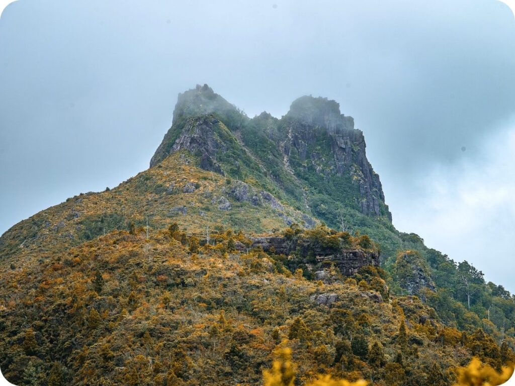
The Kauaeranga Kauri Trail, or the Pinnacles Walk, is a very popular hike in the Coromandel, and for good reason. You’ll climb up through the lush green trees of Coromandel Forest Park to the rocky outcrop forming the pinnacles. It’s a hard hike to the top, but the undulating nature of your steady climb helps to ease the effort to get up there. You’ll be surrounded by birdsong and shady paths crisscrossing Webb Creek as you go, the rocky creek banks providing you with some incredibly peaceful picnic spots to enjoy your hiking snacks.
We really loved this walk and found it to be so much more than just the view from the top. You will need some good hiking knowledge to tackle the Pinnacles, with a steep rocky climb up ladders and rungs to get to the views. There are also a few river crossings that shouldn’t be attempted after heavy rain. So check the weather before you head out, especially if you want a good view from the top! We have heard it can be rather hard to time this one to avoid the clouds hugging the Rocky Castle that is the Pinnacles. We got lucky on our trip; whilst there were clouds, they were high enough that we could still see out to the coastline and beyond!
Be sure to check out our Instagram to see more of our favourite day hikes around Aotearoa!
Details
Starting Point: Kauaeranga Kauri Trail Carpark
Distance: We hiked 14.6 km.
Duration: It took us 6.5 hrs to complete the hike, including stops for food and plenty of photographs!
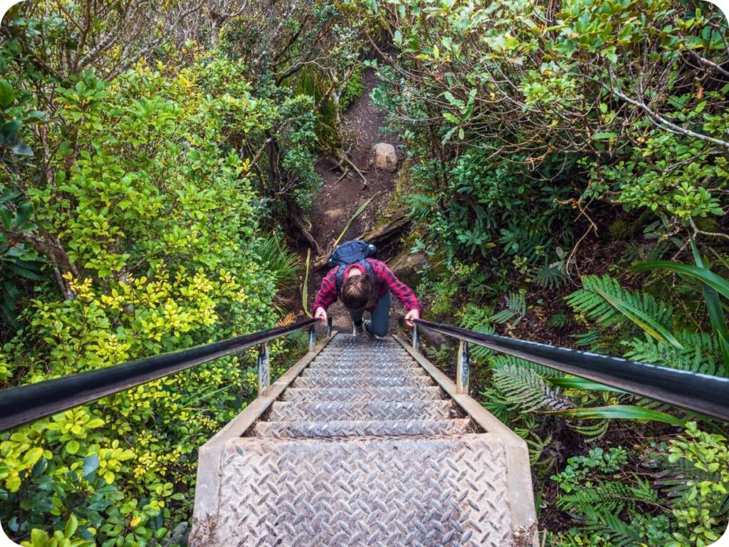
Difficulty: Hard. Although the track is relatively well formed in most places, you will have a few creek crossings as well as a tricky climb up ladders and metal rungs to get to the top viewing platform. It’s steep going with a total of 776 m elevation gain.
When: We did this in early October
Local Iwi: Ngā iwi o Hauraki acting on behalf of 12 iwi in the Hauraki region
Additional Information: You can, of course, stay overnight at the Pinnacles Hut. We have heard wonderful things about sunrise and sunset from the Pinnacles. We just don’t have the equipment for overnight hikes, so we did this as a day hike. There are, however, plenty of DOC campgrounds along the road out to the trailhead. We stayed at these the night before and the night after our hike.
Trail Map
Getting to the Starting Point of Kauaeranga Kauri Trail
The trailhead is about a 34-minute drive from the town of Thames. With a car park conveniently located at the start of the track. There is also a campground here if you have a van like us! It’s a great place to spend the night before your hike so you don’t need to wake up as early to get a morning start. Be sure to duck into the Department of Conservation (DOC) visitor centre on your way out to the car park. Just check in to make sure the condition of the track is ok and the weather is on your side for the hike.
From the visitor centre it’s a 9 km drive down the unsealed Kauaeranga Valley Road. It’s a beautiful drive down the valley with the river to your right. Just be careful as you go; the road can get quite narrow here.
The Trail
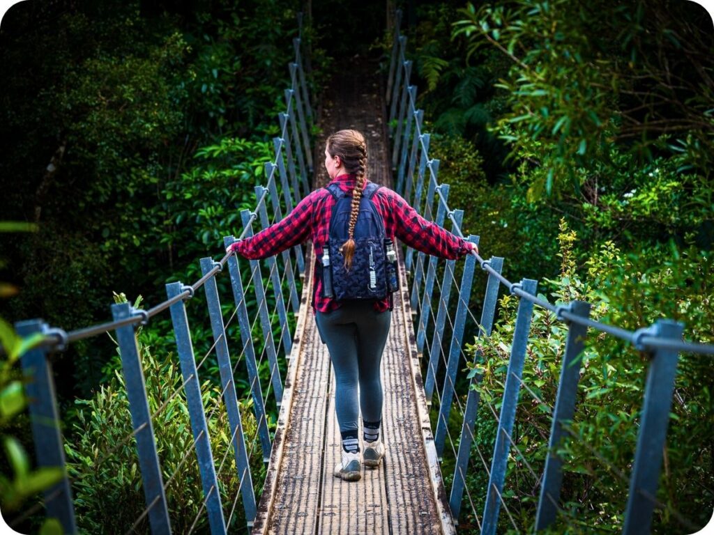
You’ll be following an old packhorse route used in the 1920s by kauri bushmen logging kauri trees in the area. The track starts off nice and easily, meandering through the lush bush on a well-formed track. The track does go a little downhill from here (the quality, not the direction; that’s all up!) with it becoming narrower, muddier and rockier. The climbs are tough, and there are plenty of swing bridges and a couple of river crossings as well. Make sure you have checked the conditions before going, as in heavy rain these rivers are dangerous to cross.
When you start the hike, you’ll come across a gate and some cleaning supplies. Please be sure to clean your boots and any gear that will come into contact with the ground to protect the precious kauri trees. If you’ve done any hiking in Northland or Auckland, you will be familiar with the process. Basically you need to remove any dirt, small rocks, etc from your shoes and then spray with disinfectant at the start and end of every hike to ensure that kauri dieback disease isn’t spread to these magnificent trees.
Billygoat Landing
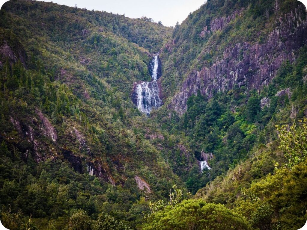
The trail starts off relatively gently, taking you through the gorgeous forest of ferns, rātā and nīkau palms. You quickly come across your first swing bridge of the track crossing the Kauaeranga River. Just after this swing bridge is a detour to Billygoat Landing. You’ll want to do this detour now rather than at the end when you are more tired. It’s a short 5 min walk, but it is up some stairs. Don’t worry, the view of the 180 m high Billygoat Falls in the distance is well worth the effort!
Webb Creek
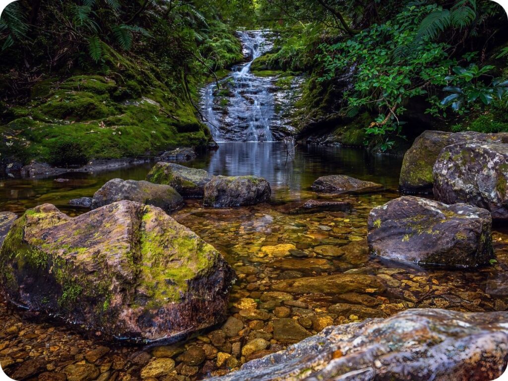
From Billygoat Falls, head back to the main track and follow the signs for Webb Creek, sticking to the right when you reach the junction. You’ll cross the creek a few times, switching back and forth with different types of crossings. The first is on a swing bridge; you’ll then climb up a rocky area and find yourself crossing the river over rocks. Be careful here, as they are slippery in places.
The rocky banks of the river are a great place for a dip or to stop for a snack whilst you admire the creek. Once you continue on climbing up, you’ll cross it once more on a wooden bridge, and finally, you’ll come to a small and somewhat scary-looking single-person swing bridge. I (Tiff) am very much not a fan of these; Nathan, on the other hand, thinks they are great fun!
Hydro Camp
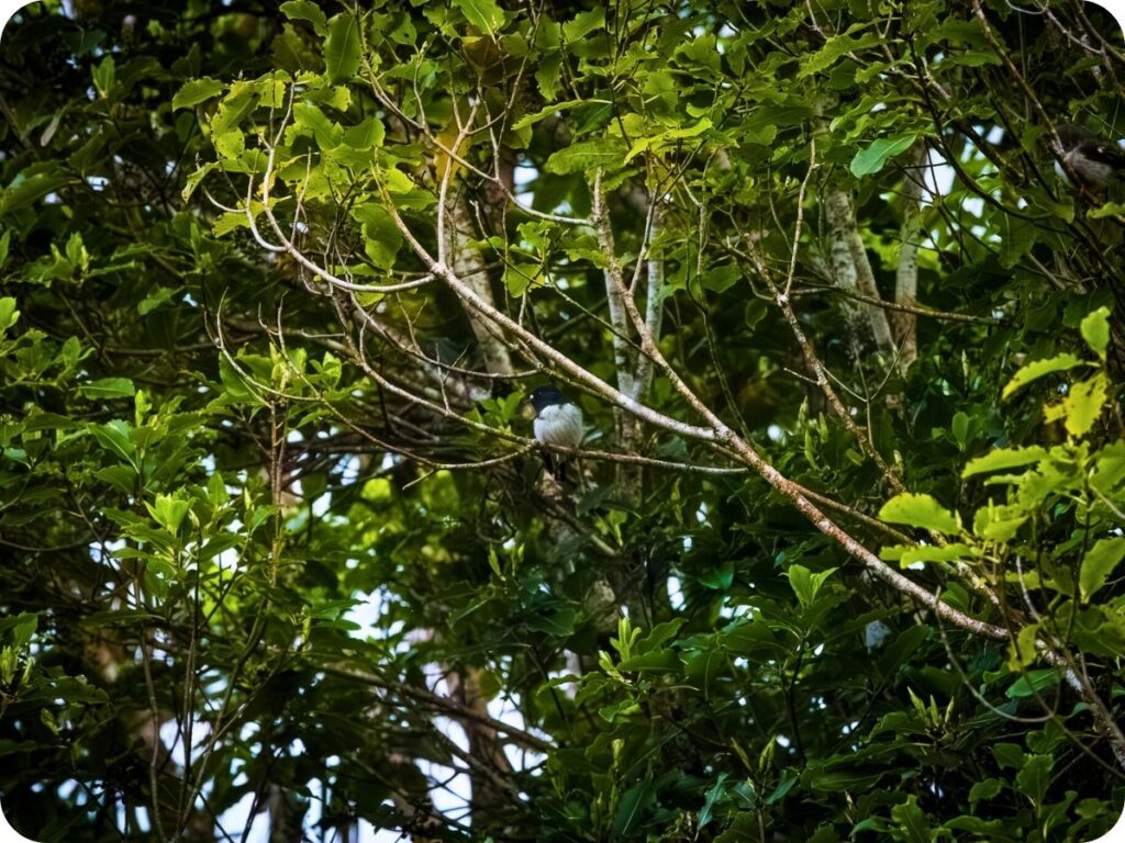
You’ll keep on climbing up, sometimes on an incline, sometimes on some stairs cut into the rock itself! Keep an eye out on the trees for the many birds that call this forest home. We saw quite a few tomtits here! You’ll soon come to a clearing in the forest known as Hydro Camp. It was cleared in the 1940s by power line workers. The power lines you come across on the hike seem rather out of place in this forest and love to make weird noises in the wind!
The hydro camp is another great place to stop for a snack. It’s a popular stopping point, as was evident by all the rubbish we picked up here. There was more than we have ever come across on a single hike. Thankfully we were prepared to pick it all up and take it back to our own bins!
Open Ridge
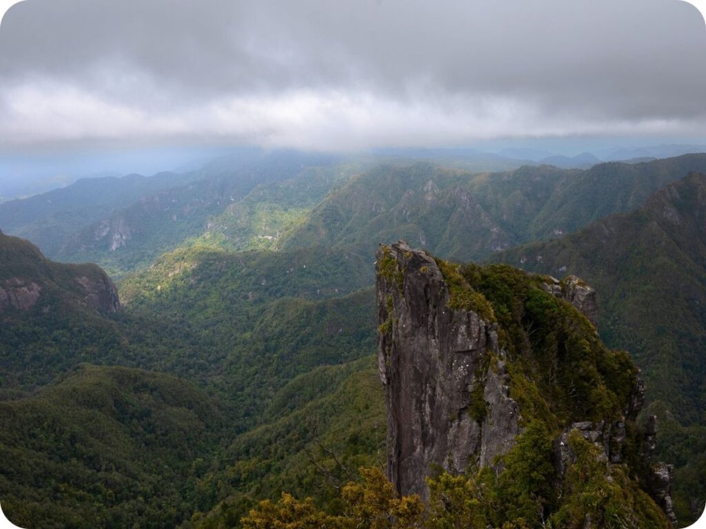
Once you’ve rested at Hydro Camp, you’ll have another little river crossing before continuing your climb up to Pinnacles Hut. Follow the Pinnacles Track as you climb around a forested hill and come out to an open ridge. The views from here are beautiful and will only get better as you go! The volcanic landscape opens up around you with jagged peaks and plunging valleys everywhere you look. You’ll get your first views of the Pinnacles from here, which still seem an alarmingly long way away. Don’t worry though; it’s not too much of a walk before the Pinnacles Hut comes into view.
Pinnacles Hut
If you are staying overnight at the hut, be sure to stop in and claim your bed. If, like us, you are doing a day hike, be sure to stop in for the only toilets on the trail. These were super clean long-drop toilets, and there were plenty of them too. From the hut your journey gets a little more difficult and a lot more upwards.
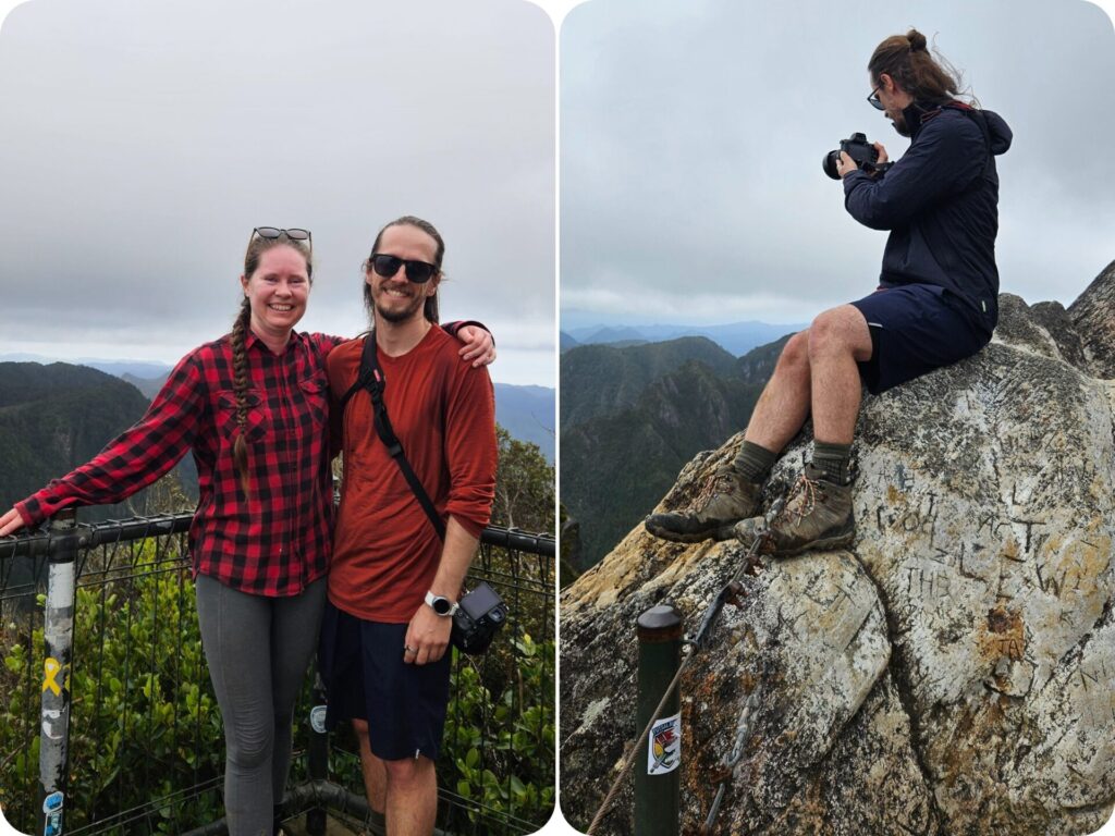
The 1km hike to the Pinnacles is steep and very exposed. It’s recommended not to go up the track in high wind or any rain. Make an assessment when you get to the hut if it’s safe to go up or not. If the weather is on your side, it’s a steep climb up a lot of steps to get to the rocky area of the pinnacles. Even the fittest amongst those climbing up were puffing away, so don’t feel like you need to power up this climb. There is nothing wrong with stopping to admire the view and how far you have come to get here!
Pinnacles Lookout
Once you reach the start of the rocky outcrop, the fun truly begins! Get ready for some ‘rock climbing’ in the form of ladders and some bolted iron rungs jutting out from the rock you are climbing up. It’s a fun climb, with steep drop-offs on either side. Hence why you don’t want to do this in the rain when all that rock and metal become very slippery. We had a lot of fun climbing up between the rocks to get to the summit viewing platform.
From here you have incredible views out over the Coromandel Forest Park, stretching all the way to the east coastline of the peninsula! The undulating land before you is full of deep valleys and soaring peaks, all of it a lush deep green. Make sure you take your time up here; you worked hard to get here!
We had a chat with the other hikers we encountered and met two Kiwi blokes who had each carried a beer up to enjoy on the summit! It was quite a laugh watching them drink their warm beer; we even helped them get a great photo (sadly we don’t have a copy ourselves). Once you have enjoyed the view and the company on the summit, you can start to retrace your steps back to either the hut or the start of the trail. Just be sure to clean off your shoes when you leave the trail.
Please Leave No Trace
As always, when out in nature, be sure to practice leave no trace. Anything that goes into the park with you comes out as well (this includes apple cores and any type of food scraps). Be sure to keep to the trails so you don’t disturb the fragile ecosystems off the trail. Please leave rocks, sticks and plants as you find them. Please don’t take anything but photographs and leave with nothing extra but memories. We like to go one step further on leave no trace by making sure we pick up any rubbish we see along the trail; sometimes people slip up and forget to pick up after themselves, or things get accidentally forgotten. If you see something that doesn’t belong and are equipped to pick it up and correctly dispose of it, please do!
To help you leave no trace on this incredible hike, we have a few blog posts for you to read! We share our tips on how to pack for an eco-conscious day hike and what to do on the trails to protect the land you are hiking on. It’s always good to know whose land you are on too! We have done our best to include the Tangata Whenua (people of the land) above in the local iwi section. However, it is always a good idea to do your own research as well. Knowing whose land you are on is vital in ensuring you can respect the customs and wishes of the landowners and help to protect their land.
Keen for more inspo? Be sure to check out:
- Day Hike – Mueller Hut
- Eco-Conscious Travel: How To Travel Sustainably In 2026
- 5 Incredible Hikes In Milford Sound Not To Be Missed