Pourangahau or Mt Robert is nestled in the Nelson Lakes National Park. There are so many hiking tracks around here and, as the name suggests, some gorgeous lakes to hike around too. The Mt Robert Circuit hike is a tough but rewarding hike. The views from the Maunga (Mountain) face are well worth the hard uphill climb to get them. It's a popular hike with plenty of huts along the way.
You'll come across many other hikers, some venturing further into the park and further up the Maunga for multi day hikes, so stop for a chat when you can. We ran into a hiking group visiting from America and had lunch together! The hike itself is hard but incredibly rewarding, with stunning views of the region. Tiff even glimpsed the ocean way out in the distance.
With stunning views come exposure to the elements. A lot of the hike is exposed, and it gets really windy up here. Weather in Aotearoa can change drastically over the course of a few hours, so pack appropriately and check the weather before heading out. There are a lot of signs on this hike warning you not to attempt it in bad weather conditions and to head back if the weather takes a turn for the worse.
We recommend spending a couple of days camping at the campgrounds of the national park so you can pick the day with the best weather to tackle the Mt Robert circuit.
Be sure to check out our Instagram to see more of our favourite hikes!
Details
Starting Point: Mt Robert Day Parking. However, if you have a vehicle longer than 7m, you can't drive further than the west bay DoC campsite. We recommend staying the night here so you can park in the campsite and walk the road up to the start of the track.
Distance: 9.6km from start of track. 16kms from West Bay Campsite.
Duration: 5 and a half hours if walking from the campsite.
Difficulty: Hard. That extra 3.6km down the road on the way down is not fun!
When: We did this one in March. You'll want to go on a clear day to make the most of the views.
Local Iwi: Ngāti Koata, Ngāti Rārua, Ngāti Tama ki Te Waipounamu, Ngāti Kuia, Te Ātiawa, Ngāti Toa Rangatira, Ngāti Apa ki te Rā Tō and Rangitāne o Wairau.
Additional Information: There are a lot of exposed sections on this track, so be sure to check the weather and check in at the information site before taking on this hike. Weather changes quickly in Aotearoa, so be sure to pack for all kinds of weather.
Trail Map
Getting to the Starting Point of Mt Robert Circuit
We didn't realise that you can't drive a vehicle over 7m to the starting car park of this hike until we got to the sign telling us we couldn't go any further. It was rather disheartening to have to turn back and leave Vandalf (our campervan) at the campsite. Nathan, in particular, was very upset about the extra walking we'd have to do.
It turned our half-day hike into a proper full day hike! So don't be like us, be prepared with either a small enough vehicle to drive you to the Mt Robert Circuit day parking area or give yourself plenty of time to walk to the carpark at the start of the hike.
The Trail
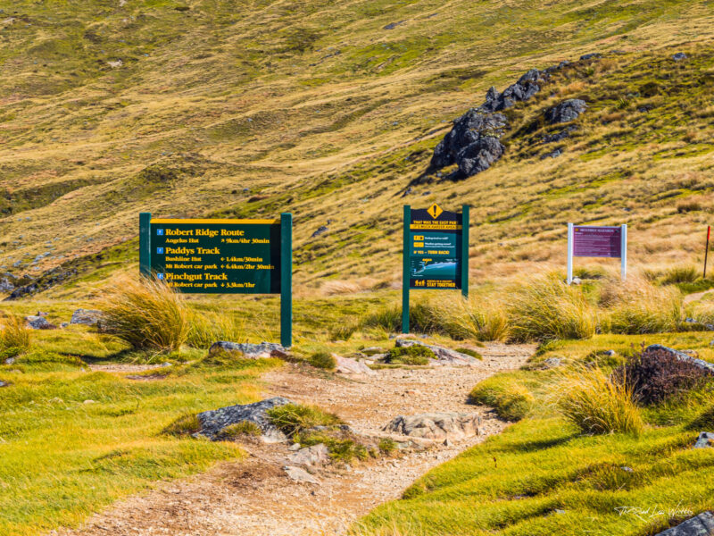
Once you get to the start of the actual trail at the day car park, there are two options for where to start. Given that this is a circuit, you can walk it in either a clockwise or anticlockwise direction. We opted to walk in a clockwise direction, starting with Paddy's Track, as it is a gentler ascent.
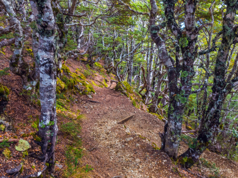
You'll start off with a climb through the beech forest with lots of small plants to stop and admire along the track. We stopped a lot to look at small flowers, moss-covered trees and rocks and Nathan's favourite, mushrooms! Be sure to take in both the sweeping views and the smaller ones along this hike.
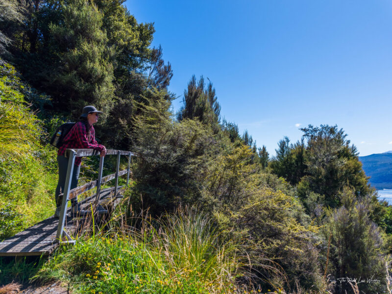
Bushline Hut
It's a steady, relatively gentle but long, uphill climb up to Bushline Hut. The views behind you on this climb are worth stopping for to take in every once in a while. They also offer a great excuse to stop and catch your breath. The track is easy enough to follow, but if you want to see where it is leading, you follow the line of tall orange markers snaking up the face of Pourangahau above you.
About 30mins before you reach Bushline Hut, you'll come across a shady little stream with a few trees that seem out of place on the tussock covered Maunga. This is a great spot to catch your breath, especially on a summer's day before climbing the rest of the way to Bushline hut.
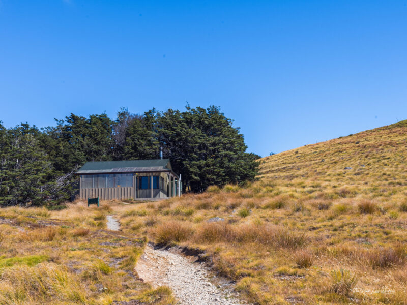
Kea Hut
Follow the track behind Bushline Hut and through the alpine forest to find the cutest ski hut we have ever seen! Kea Hut is not open to the public, but it does have a cute bench out the front to stop for a snack. The hut was built in 1934 by 6 skiers to create a base for organised skiing in the national park. The hut is now maintained by the Mt Robert Snow Sports Club and looks incredible even when there is no snow surrounding it.
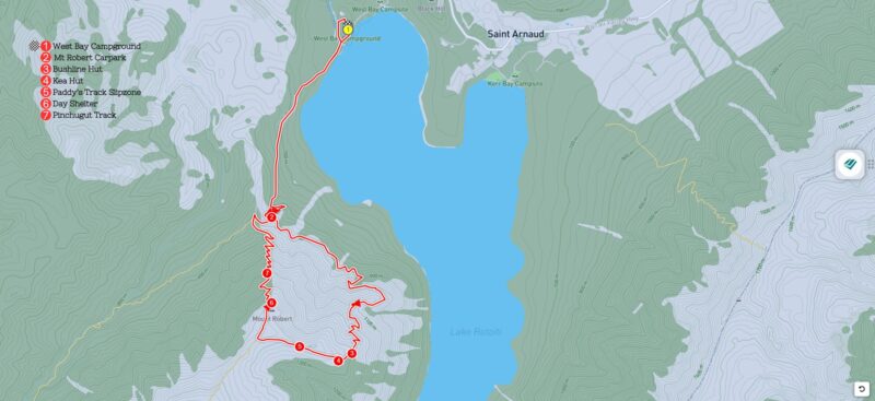
Slip Zone on Paddy's Track
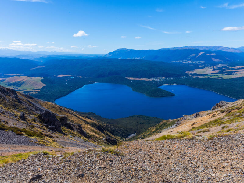
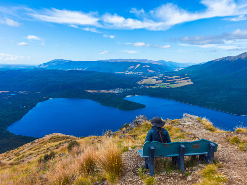
Once you have passed Kea Hut, the journey gets a lot easier. It's fairly flat on this stretch, but the wind can get quite strong here. Be careful as you pass the slip zone to the right of the track, but do stop to take in the views. It is from here that on a clear day you may catch a glimpse of the ocean in the very far distance! Tiff could see it, but Nathan couldn't.
Continue along the track until you reach the T intersection for the Pinchgut Track to the right and the Robert Ridge Route to the left. We laughed at the sign here telling us what we had just done was 'easy' and if you didn't think so, don't continue on to the Robert Ridge Route. We had no plans of going up the ridge, so that was lucky! Continue on the Pinchgut Track to the right for a quick few minutes before you reach the day shelter.
Day Shelter
We stopped here inside the shelter for some lunch and to get out of the wind. We were a little surprised to find it was packed when we opened the door! There was an American hiking group taking refuge from the wind as well. We actually ended up chatting together for a while whilst we had our lunch. Some of the group split off the hike part way up the Robert Ridge Route!
We love meeting different people on our hikes and having a chat whilst you all enjoy the view and your own food. This group was full of over 50s and they'd come from a hike the day before too! If you don't plan to have lunch in this little hut, make sure you do step inside to admire the view from a unique vantage point out the window from the hut.
Pinchgut Track
After the day shelter, the track is pretty much all downhill! Yay! You'll find some very well placed benches along the Pinchgut Track, so make sure to stop at them all. Yes, Tiff sits down at every bench we come across on a hike. It would be rude not to! But these benches are some of the most well placed we've seen in a while. They take in the incredible views and are well spaced enough that you feel like a little rest each time you reach a new one.
The descent is steep, so whilst it's not going to puff you out per se, it is hard work on your legs! Once you descend back down to the beech forest, stop for a minute and take in the sounds of the many birds singing to you as you finish up your hike.
A tough but rewarding hike, just make sure you are well prepared for the elements and bring plenty of food and water with you. Whilst hiking it's important to put into practice the principle of 'leave no trace'. This means packing out all your waste and rubbish as well as not taking anything from the trail. Rocks, flowers, leaves, branches everything natural needs to be left as it is.
Really, the only thing you should be picking up on any hike is any rubbish you see along the way.
It's also important to keep to the path provided so you don't harm the natural environment you are there to enjoy! It's also really important to respect the land you are on by researching the local Iwi and ensuring you don't do anything disrespectful whilst on their land. We choose not to summit mountains in Aotearoa and won't eat anything whilst we are close to a mountaintop as a sign of respect. The summit of the Maunga is the most Tāpu (sacred) and is likened to being the head of Māori ancestors.
For more info on 'leave no trace' and respecting the land you are on, check out our blog post on how to be an eco-conscious hiker.
Keen for more inspo? Be sure to check out:
Want to know more about our story?