The Mount Somers area is a stunning part of Aotearoa that is often missed by travellers for the more impressive southern alps. It’s incredibly popular among locals, though, so don’t miss out on this gem of a day hike. Woolshed Creek Hut is part of a longer multi day hike, so you can spend the night here if you have the gear to do so. We found the day hike loop track perfect to get a taste of the area and still sleep in the comfort of our own bed at night.
This track is full of incredible mountain vistas, bubbling streams, swimming holes, waterfalls and lush native bush. You get a feel for an alpine hike without the huge climbs. It packs a punch as a day hike and made it to Nathan’s top 5 South Island day hikes, bumping out Abel Tasman, so you know it’s good! Pack your camera and a good pair of hiking boots and be prepared to spend the entire day out here soaking up all the views and fresh air that Mount Somers has to offer.
Be sure to check out our Instagram to see more of our favourite hikes!
We didn’t plan it, but this turned into a sunset hike. We happened to pick the day after daylight savings ended to do this hike. Now, we are from Western Australia, a place that does not have daylight savings. We do not like, nor are we used to, daylight savings. So of course we forgot that daylight savings had ended, and thus the sun would be setting an entire hour earlier than it did the day before.
We did not pack head torches because we thought we had ample time to do the hike in daylight. We also took a lot longer doing this one than planned because we took so many photos and got distracted by side quests. So please learn from us and pack at least one head torch on a long day hike. You never know when you might end up needing it!
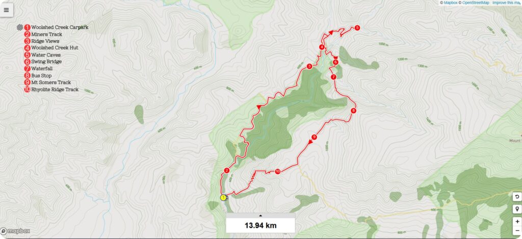
Details
Starting Point: Woolshed Creek Carpark
Distance: 15km
Duration: 8 hrs including lots of stops
Difficulty: Moderate
When: We did this in early April, you wouldn’t want to do it in the heart of winter as snow will become an issue on the upper parts of the track. Make sure you check weather conditions before heading out.
Local Iwi: Ngāi Tahu
Additional Information: If you want to stay and watch the sunset over the valley from the top of Rhyolite Ridge Track, like we did, make sure you pack some head torches to get yourself safely back down the zigzagging track to the car park.
Trail Map
Getting to the Starting Point of Woolshed Creek Hut Track
The track starts at the Woolshed Creek car park on Jig Road. It’s an unsealed road of about 4km, but when we drove along it, it wasn’t in too bad of a condition. There is ample parking here as the walk is popular and part of a longer multi-day hike in the Mt Somers area.
There is a map with trail times and toilets here before you start your hike. We highly recommend staring this one early and giving yourself ample time to take in all the sights and even go for a swim if the weather is on your side.
The Trail
Miners Track
Start this loop track off by following the Miners Track up to Woolshed Creek Hut. The track starts in the bush to the left of the main sign in the car park. The incline starts here, but is relatively gentle as you follow the creek along for the first km or so. You’ll soon come across some relics of the mining days, with some rusted wagons to the right of the track.
Follow the trail straight ahead, and you’ll soon come to a little creek crossing and the start of a steeper ascent. At the top of this climb you’ll find the entrance to the old mine. A great place to stop for a snack! It does get busy here though, we didn’t stop as there was a large hiking group and kids everywhere!
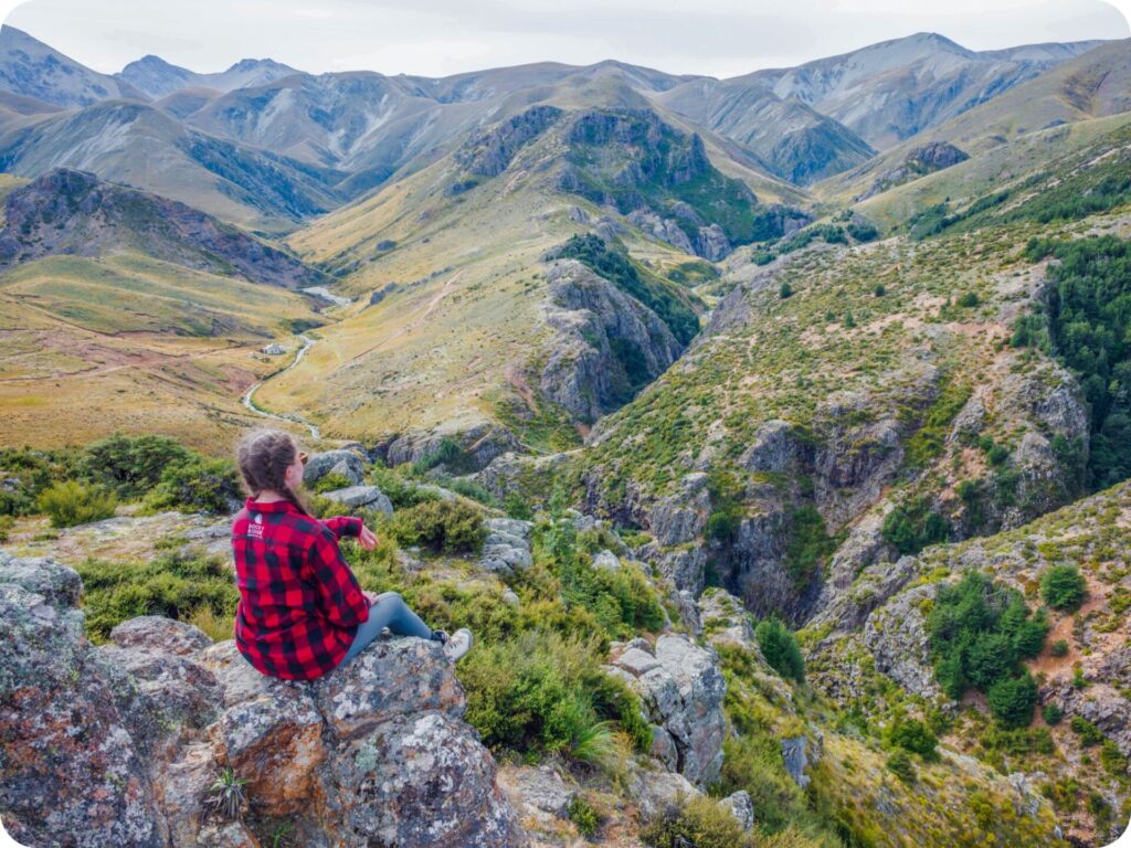
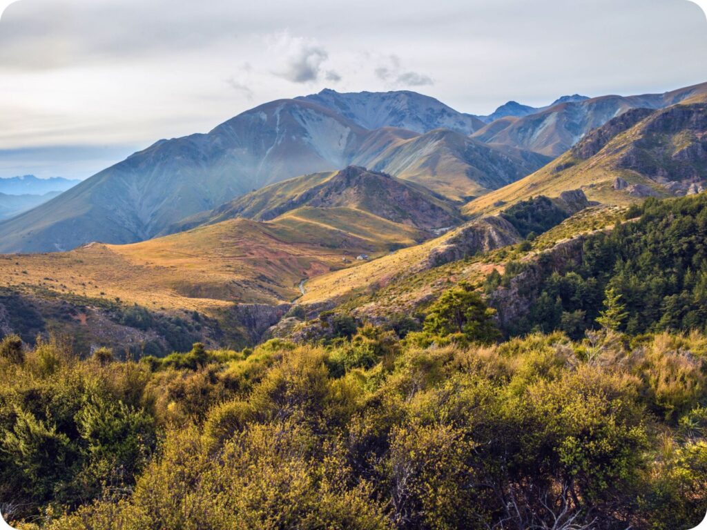
Ridge Views
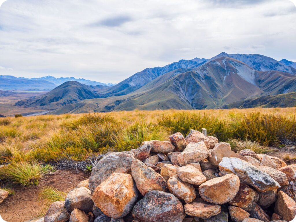
You’ll get a bit of a break from your climb after the mine site with a nice flat stretch before starting another more difficult climb. The track becomes narrower and skirts around cliffs before taking you up a rocky ridge. The top of the climb is marked with a rock cairn (the only kind of rock stack you want to see on a hike, as this one is meant to be here) which makes for a great snack stop.
Enjoy the views on both sides of the ridge here. The Southern Alps to the left and the valley and a few waterfalls to your right. You’ll have a gentle descent to another great lookout over the gorge and your first views of Woolshed Creek Hut.
Woolshed Creek Hut
From the rocky top of the track where you get your first glimpse of the hut, you’ll start to climb down a steepish track. There are boardwalks in places to help stop hikers slipping, which would be especially helpful in the winter months.
Make sure you stop to take in the little pools below you in the creek as you walk the rest of the way up to the hut. There are toilets here and a few picnic tables.
We chose to continue on instead of having lunch here, as we were keen to eat by the stream at the Water Caves.
Water Caves Side Track
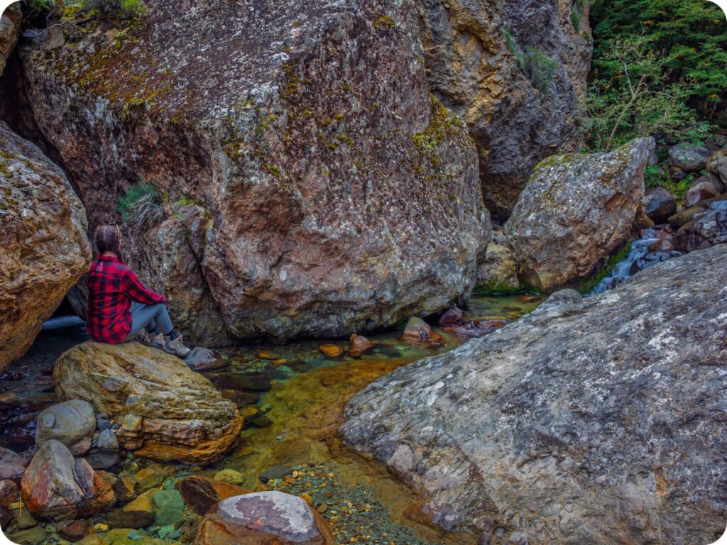
Cross the river in front of the hut and follow the track to the right and up the hill in front of you. At the junction about 50m or so along the river, take the left turn and follow the steep incline to the water caves. You won’t see them on a sign, so be sure to follow the Mt Somers track signs at first. It’s a steep but short climb that winds its way back down to another creek crossing.
After you cross this creek, the track follows it upstream and up another incline before you’ll see a little sign pointing to a side track and the water caves. They aren’t really caves as such. More like a maze created in the river by boulders that have rolled down the hills and sit precariously against each other, creating the ‘cave like’ effect.
It’s a great spot to wade through the water and explore. The pools can get quite deep, and the water was very cold when we were here. We didn’t swim, but we did get our legs wet. Once you have enjoyed the ‘caves’ retrace your steps to the track junction in front of the hut and continue on straight taking the Mt Somers Track.
Swing Bridge
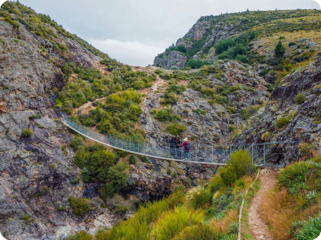
If you aren’t a fan of swing bridges and aren’t after a tough climb back to the car park, you can always take the Miners Track back and do this as a there and back hike instead of a loop hike. We loved taking the Mt Somers track, even though it is harder than the Miners Track and has this terrifying swing bridge that is only rated for one person at a time!
Tiff had a hard time crossing this one, quoting donkey from Shrek the entire time. Nathan, on the other hand, chose to stop halfway and take pictures! The tough climbs start now, with a big push to get up and out of the gorge. You’ll climb up and down again just as quickly, with a stream crossing just before the side trail to a waterfall.
Waterfall Side Track
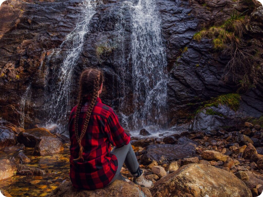
Don’t miss the waterfall side track! Once you cross the stream, there is a quick climb up its banks, and you’ll see a sign pointing to the left that says waterfall. Someone has crossed out the 5 mins and replaced it with a one.
A quick detour that is well worth it! Just be careful on the rocks here, as Nathan slipped and banged his shin pretty good.
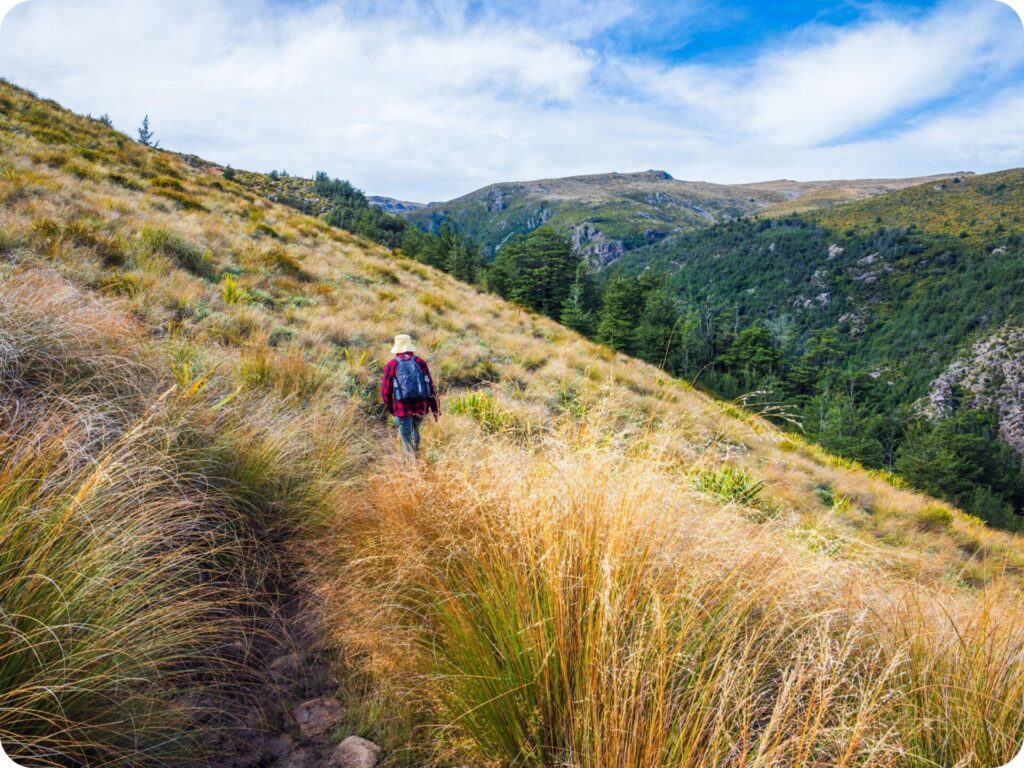
Enjoy this flat side track because the real climb starts right after it. Thankfully the climb has some epic views over the valley and out to the southern alps, so you have plenty of reasons to stop and catch your breath. We got to watch clouds rolling into the valley from the unique position of being above the clouds! It’s a really cool part of the hike and worth taking your time to enjoy.
Bus Stop
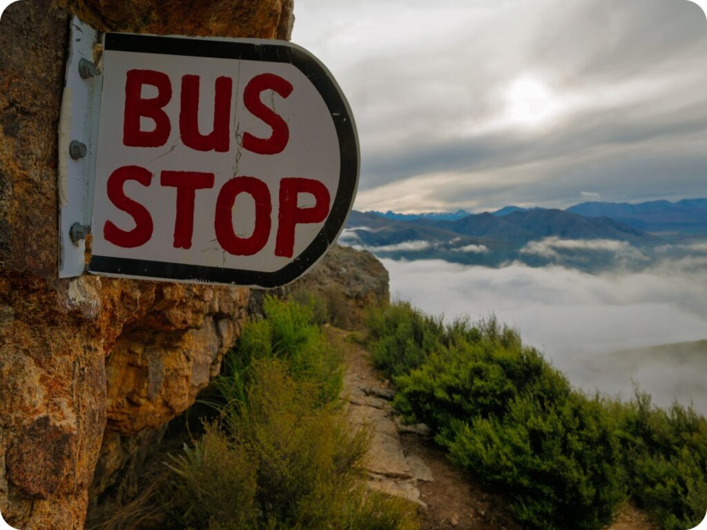
You’ll know you’ve finished the climb when you reach the orange rocky overhang and the Bus Stop sign! Yes, there is a bus stop on this hike. Just don’t get too excited thinking you’ll get a lift back to the car park. You’d be waiting all night at this bus stop! Why there is a sign for a bus stop here we have no idea.
Presumably someone who has a great sense of humour put it there. It is fun to dream about an air-conditioned bus ride back to the car park after a tough climb, so stop here for a snack and a laugh before heading on your merry way.
Mt Somers Track
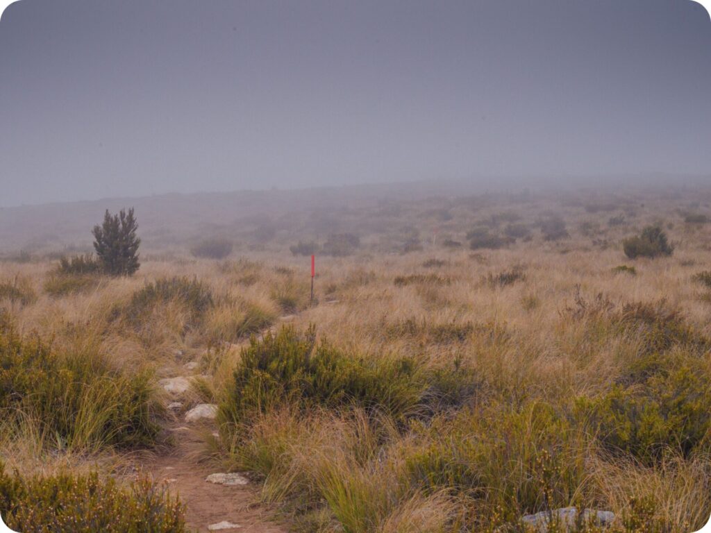
It’s now a much easier track through scrubland and over boardwalks for a way before you start the first of the descent back to the car park. The track then flattens out again over boardwalks and across scrubland. The clouds were closing in on us, so we had a very misty walk through this section.
We hear the views are great, all we saw was white! Thankfully, it’s an easy-to-follow straight track before hitting an intersection with the Rhyolite Ridge Track and the Mt Somers multi-day loop track. Follow the signs for the Rhyolite Track to the right.
Rhyolite Ridge Track
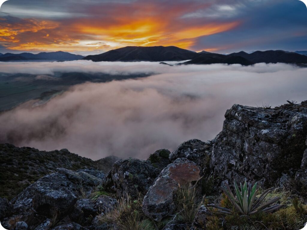
You’ll continue along the ridge before reaching the rocky top and stunning views out over the valley below. We were fortunate enough to have the clouds part just as the sun was setting. How could we not stay up here and enjoy the sunset when it looked like this?!
We did regret staying as long as we did on the climb down. The descent is steep, with quick zigzags going down between the cliffs. With fading light and only phone torches to guide us, it wasn’t a fun path down the mountain. It’s an easy track to follow, though, and we soon found ourselves crossing the bridge over the Woolshed Creek to get ourselves back to the car park.
Extra Tips/Info for Woolshed Creek Hut Track
If you are staying near the track overnight be sure to check out the Ōpuke Hot Pools the next day. A great way to soothe tired muscles and relax after a day out in the mountains. This was our ‘shower’ after the hike as we freedom camped nearby. They actually have showers to use after the hot pools which was an added bonus for us vanlifers!
Please Leave No Trace
As always, when out in nature, be sure to practice leave no trace. Anything that goes into the park with you comes out as well (this includes apple cores, any type of food scrap, wrappers ect). Be sure to keep to the trails so you don’t disturb the fragile eco systems off the trail and leave rocks, sticks and plants as you find them.
Please don’t take anything but photographs and leave with nothing extra but memories. We like to go one step further on leave no trace by making sure we pick up any rubbish we see along the trail, sometimes people slip up and forget to pick up after themselves. If you see something that doesn’t belong and are equiped to pick it up and correctly dispose of it please do!
To help you leave no trace on these incredible day hikes we have a few blog post you should read! We share our tips on how to pack for an eco-conscious day hike and what to do on the trails to protect the land you are hiking on. It’s always good to know who’s land you are on too! We’ve provided that here to the best of our knowledge but recommend you do your own research too, making sure you respect the wishes of the traditional owners of the land at all times.
Keen for more inspo? Be sure to check out:
- 6 Day Itinerary For Rakiura (Stewart Island)
- 10 Free & Cheap Things To Do In Wānaka
- Essential Road Trip Tips for an Unforgettable Journey!