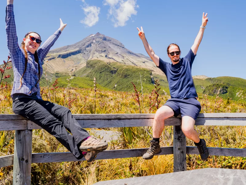
Pouākai Crossing is said to rival Tongariro Alpine Crossing as the best day walk in Aotearoa, New Zealand. We are yet to do Tongariro but we LOVED Pouākai Crossing. It will be a close fight for the title of best day hike. The views you get along the Pouākai Crossing are breath-taking. It's a challenging hike but well worth the effort.
You'll enjoy sweeping views out over the coast and even to Mt Ruapehu if the weather is right. Tramping (Kiwi for hiking) across a wide range of terrain. This 21km hike packs in all the highlights of the National Park surrounding Taranaki. Be ready for a day of challenging uphill climbs, a few rocky scrambles and the best views you could imagine!
Be sure to check out our Instagram to see more of our favourite hikes!
Details
Starting Point: Te Papakura o Taranaki. The National Park Visitor Centre
Distance: AllTrails – 19km. We did 21km.
Duration: It took us 8 hours. Allow 8-10 hours.
Difficulty: Hard. Many stairs and steep sections.
When: We did this in late December, just before new years
Local Iwi: Taranaki iwi
Additional Information: It's a point-to-point hike. You'll need to book a shuttle or find a friend to pick you up from the end.
Trail Map
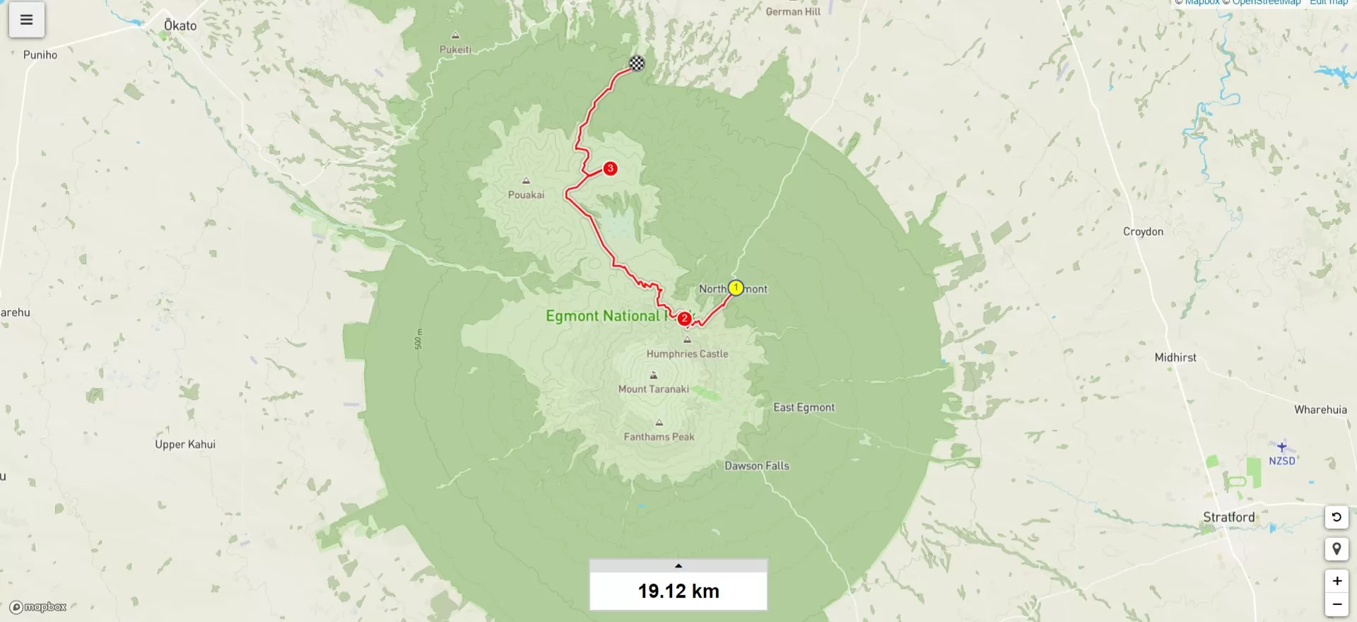
Getting to the Starting Point of Pouākai Crossing
Consider using Taranaki Mountain Shuttle ($45pp) to get to the start of the hike at the Taranaki National Park Visitor Centre. We parked at the end of the track on Mangorei Rd and caught the shuttle from here to the Visitor Centre to begin our walk. This means there was no waiting on a shuttle to pick us up at the end, nor did we have to time our walk to the shuttle's schedule.
If you don't have a car, the shuttle offers pick up and drop off from New Plymouth. However you decide to travel to the visitor's centre, be sure to check in with them before you head off along the trail. They'll be able to tell you about the tracks current condition and give you any info you need on the weather for the day. Once you've done that, make use of the toilets before following the signs for the Holly Hut to start your hike.
The Trail
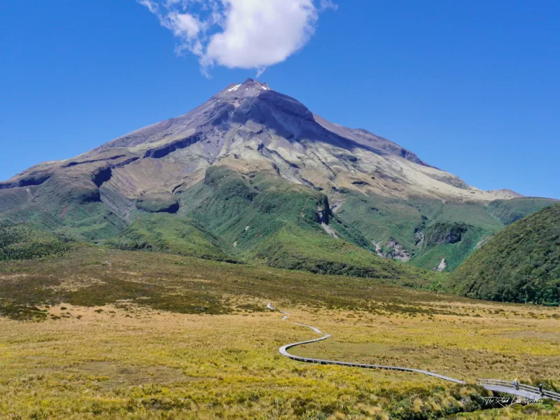
You'll enjoy stunning views of Taranaki throughout this hike. It's sometimes an effort to stop taking photos of it if we are perfectly honest. Taranaki is a majestic 2518m volcanic cone with a picturesque snow cap all year round. The youngest of the three volcanoes in the area, it is still active. With a significant eruption expected roughly every 500yrs.
The legend and movement of Taranaki Maunga has been recounted by local iwi for centuries. Taranaki is connected to the Maunga of the central north island in these legends. Originally known as Pukeonaki, the Maunga stood with Tongariro, Ruapehu and Pihanga. Tongariro and Pukeonaki (Taranaki) fought over the beautiful Maunga Pihanga. When Tongariro won, Pukeonaki retreated underground along the Whanganui river, resurfacing near the Pouākai ranges. For a better telling of the full legend visit: https://taranaki.iwi.nz/our-history/
Razorback Ridge
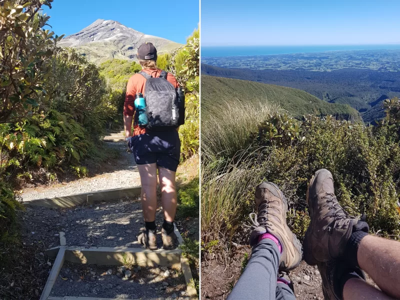
The track starts on an incline and keeps going to lead you to Razorback Ridge. Make sure to stop at the few viewing platforms on the way up to the ridge to enjoy the view, but also catch your breath. The ridge makes for a great shot up towards the summit of Taranaki and is rather cool to walk along with drops on either side. If it's windy, be sure to hold on to your hats as Tiff almost lost hers here!
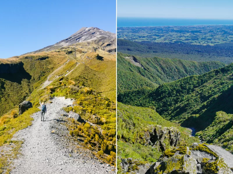
From the ridge, the track curves along the side of Taranaki with incredible views out to the ocean and dramatic drop offs and rock faces to accompany you. It's impressive to turn around every once in a while to see the trail snaking along the side of the mountain. Once you've reached the highest point of the hike at 1357m up the face of Taranaki, you'll come across an avalanche zone with a bit of a scramble over rocks to cross it. There are plenty of signs letting you know it's coming up and not to stop when you cross the loose rocky area.
Taranaki & Pouakai Viewpoint
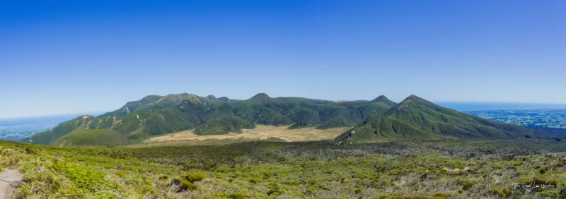
As you continue to walk along the face of Taranaki, you will slowly notice Pouākai coming into view on the horizon. Pouākai last erupted roughly 250,000 years ago, making it an impressive sight to behold. You'll start to descend Taranaki and make your way towards Pouākai. Turn around every so often to take in the view of Taranaki and the old lava flows running down its side.
As you continue making your descent, you'll come across a side track to Holly Hut. It's about a ten-minute detour to the hut. There is a long drop toilet and indoor tables and benches to sit and have a snack. If you have time and there has been recent rains, Bells Falls is located past the hut. We didn't add this to our hike as the Visitor Centre informed us there wasn't really enough water flowing to make it worth the detour. Another reason it always pays to check in at the visitor centre before taking on any hike.
Ahukawakawa Swamp
After your descent down Taranaki, you'll come to the Ahukawakawa swamp. Before you enter the swamp, there is a little seating platform with a few plaques telling you about the surrounding area. Another possible snacking location, although it doesn't offer any shade. We stopped here to take in the view of Taranaki and out over the swamp to Pouākai, but continued on our way, hoping for a more shaded area to enjoy our lunch. To cross this 3500-year-old swamp you will walk along a 1km boardwalk. Stop about halfway on the boardwalk to take in the majestic form of Taranaki behind you before continuing to the bridge crossing the clear waters of Stony River.
Pouākai
The climb up Pouākai is the hardest part of the hike. The first ascent up some incredibly steep stairs requires the most effort. Thankfully, you can stop every few flights to take in the stunning view behind you. We probably didn't need to stop as often as we did for photos on this part of the hike, but we definitely needed those stops to catch our breath!
Once you've climbed the stairs of doom, the ascent levels off a little, but it's still a relatively steep climb to get to the top and the saddle. You're rewarded for your efforts with more sweeping views out over New Plymouth and a different angle to admire Taranaki. We ate our lunch here, finding some shade in the lip of a rock along the track. From here, you follow along the side of the mountain before descending on the Mangorei track.
Pouākai Tarns
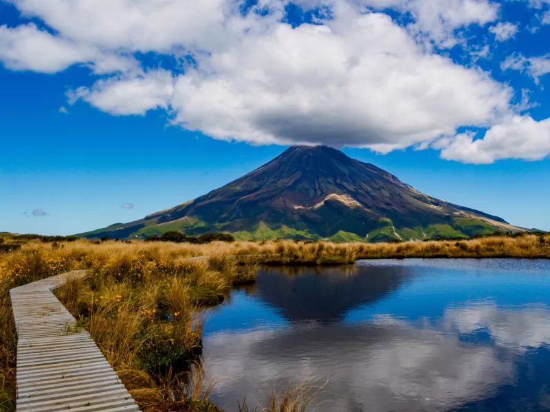
The official route for the Pouākai Crossing doesn't actually include the Tarn, but you'd be silly not to make the detour down to the famous Instagram location to capture the reflection of Taranaki in the sometimes still waters of the tarn. If you've seen the picture before coming here in real life, you may be a little disappointed. Whilst it makes for a great shot, the tarn itself is more of a shallow puddle than the lake you believe it to be in the pictures.
The surrounding boardwalk is also crowded with people trying to get 'that shot'. It's still worth the detour to take in the views, but we didn't stay amongst the crowds for too long, especially as the wind was creating havoc with the reflection of Taranaki in the water. We found sitting on the large rocks just before the turnoff to the tarn to be a much nicer place to relax and take in this side of Taranaki whilst we had another snack. Yes, we pack enough snacks so that there are always more than we need. You never know when the view will provide you with a place to stop and eat some trail mix or a piece of fruit!
Rainforest Home Stretch
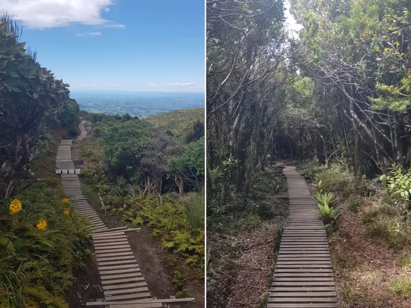
Follow the Mangorei track downhill for the remainder of this hike. It's a rather steep descent that we had been looking forward to all day. We quickly realised this was hard in a different way than the climbs we had done during the hike. In retrospect, it was probably the more troublesome part of the hike on our knees and calves, especially.
Make sure to stop a little and enjoy the last of the views of Taranaki and the coast before you descend into trees. The lush rainforest is home to some of the last Rimu and Miro trees. They provide a beautiful presence on the rest of your way down to the parking lot. If it's been a hot sunny day, the shade from this forest is extra welcoming after being out in the open for most of the hike.
Extra Tips/Info for the Pouākai Crossing
If you are vanlifers like us, we suggest staying at Volcanoview for the night. It's not as far of a drive as New Plymouth and it's much cheaper than the campsites in the city. They have showers and a restaurant open for breakfast, lunch and dinner. After a hard day hiking a good shower, delicious food and an ice cold beer was just what we wanted! The food was delicious, and they had a wonderful vegetarian option of eggplant parmigiana too.
If impressive views and hiking along an active volcano are your thing, then you cannot miss out on this hike! As you can see, it's incredible. Do it on a nice day with little to no cloud, so you can take in all the views on offer. With little to no cover provided by any trees for the majority of the hike, we'd recommend not doing this on a scorching day or when it's raining too much.
We hung around New Plymouth for a few days watching the weather forecast and picking the perfect day to do the hike. Not too hot, but no sign of clouds. Luckily, we got the perfect day for it. We hope you are as lucky as we were with the weather!
Keen for more inspo? Be sure to check out:
- Day Hike – Auckland Coast to Coast
- 6 Steps for Eco Conscious Travel
- Waterfalls in Waikato That You MUST Visit