The Routeburn Track Day Walk is a highlight of the Queenstown/Otago region and not to be missed! It’s part of the great walk, so you can actually do the entire thing in a few days by staying at the huts along the track. However, if you don’t have all the gear for a multi day hike, don’t have the time or multi day hikes intimidate you (like they do us) then the day walk is a great option to still experience part of this incredibly popular and well known great walk.
The views down into the Routeburn Valley are breathtaking and well worth the climb to get them. Before you break the tree line you are well shaded on this one, walking along the river and taking in rock formations, waterfalls and lush green bush. So strap on your hiking shoes and hit the track with us!
Below we have everything you need to know about the day hike with its main stops and views to get you excited about the adventure that awaits you.
Be sure to check out our Instagram to see more of our favourite hikes!
Details
Starting Point: Routeburn Shelter Car Park
Distance: 23km
Duration: 7 hrs, including snack and lunch breaks
Difficulty: Moderate
When: We did this hike late January
Local Iwi: Ngāi Tahu
Additional Information: The Lake Sylvan camp ground is a D.O.C site close to the start of the hike. If you have a van or like to tent we recommend staying here before and after the hike so you don’t need to drive to and from either Glenorchy or Queenstown on the day of your hike.
Trail Map
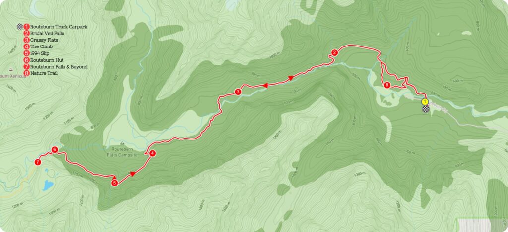
Getting to the Starting Point of Routeburn Track
The car park at the start of the trail is 25km out of Glenorchy a small town on the north end of lake Wakatipu. The last 9km of the road is unfortunately gravel, and it was not well-kept when we drove it. Give yourself extra time to get out here, as you will have to drive slow on this one! It was very corrugated when we drove along it and not at all pleasant in the van. There are toilets and information boards at the Routeburn Shelter.
The Trail
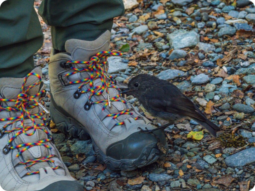
You’ll start by crossing the first of many swing bridges over the Routeburn River. From here, the well maintained track follows a gentle but steady incline through a lush green forest of beech trees, moss and ferns. You’ll see birds flitting through the trees and if you’ve come on a sunny daylight filtering through the trees in incredibly beautiful displays. We meet a very friendly robin on this part of the track that tried to taste our rainbow shoelaces! The next swing bridge you come across will take you over Sugar Loaf stream to a slightly steeper incline in the track.
Bridal Veil Falls
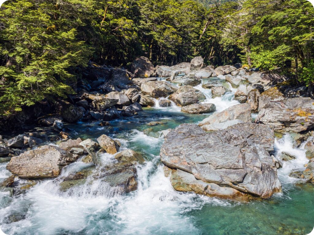
As the trail continues a gentle climb, you’ll come across a wooden bridge over an impressive gorge. The gorge has been carved out by the Bridal Veil Falls. If heights aren’t your thing, don’t look down into the gorge as you cross it, it’s further down than you would expect!
The rock formations here really are worth looking at, though, with the water steaming down and carving out little pools along the way. Please listen to the signs here asking you not to cross the railing and stay away from the gorge. If you really want to be able to cross the railing, then look into one of the canyoning tours that start from this very bridge!
The impressive carved rock will stay with you for the next part of the walk as you meander through the Routeburn Gorge. Make sure you stop and take the chance to peer down the edge of the track to the rock pools in the river below.
Grassy Flats
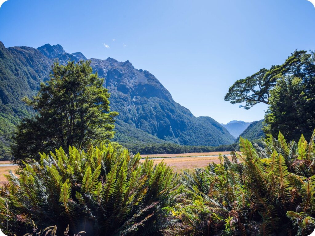
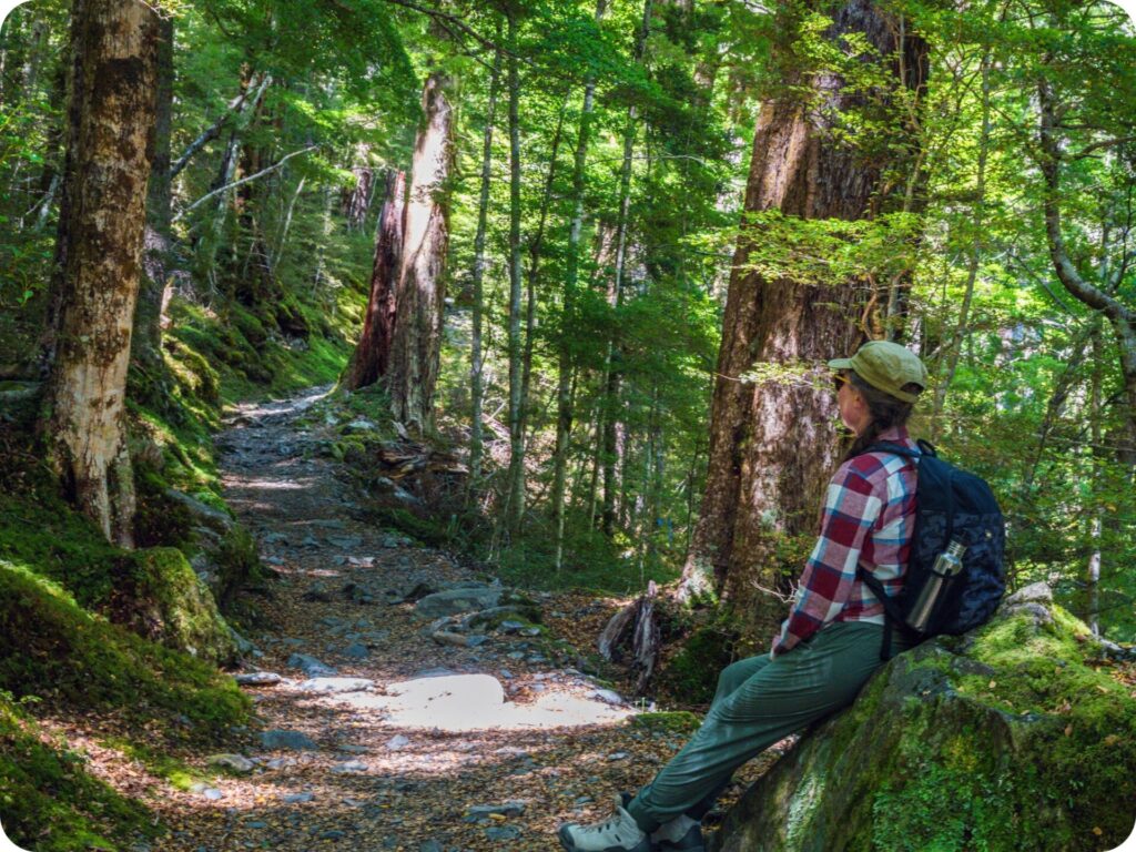
The track levels out and become flat at the Forge Flats. Here, you can take a short detour down to the river, where a lot of people stop to have a break or even a swim at this turn in the river. Continuing on the track will take you to another swing bridge crossing the Routeburn River and more flat, easy walking as you come to the valley floor.
There is a beautiful tussocky clearing here for you to sit down and take in the enormity of the mountains surrounding you. The ideal spot to rest your legs and have a snack before taking on the more challenging part of the hike.
The Climb Begins
You’ll soon come to a fork in the road at the end of your nice, leisurely flat walk. Here, you can either continue on straight to Routeburn Flats hut, where a lot of people choose to end their day walk. For those of us who like a challenge and a breathtaking view, follow the track to the left and begin a steep and steady climb up to the Routeburn Falls Hut.
This steep climb is made just a little bit harder by the rocky track here, so be careful and watch your step. When you reach the Emily Creek swing bridge, you are halfway on your climb! Be careful after the bridge as there are a few sections prone to rock fall. These are well sign posted, and it’s recommended not to stop in these areas.
1994 Slip
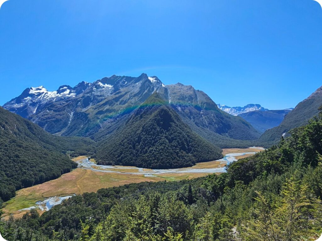
You’ll find your views improve dramatically at the 1994 slip, where a huge landslide has taken out most of the trees that were previously blocking your view on the hike up this steep section of the track. Be careful here but make sure you take in the incredible unobscured view of the Humboldt Mountains. Keep on climbing, and you’ll soon find you’ve reached the tree line and the impressive Routeburn falls hut.
Routeburn Falls Hut
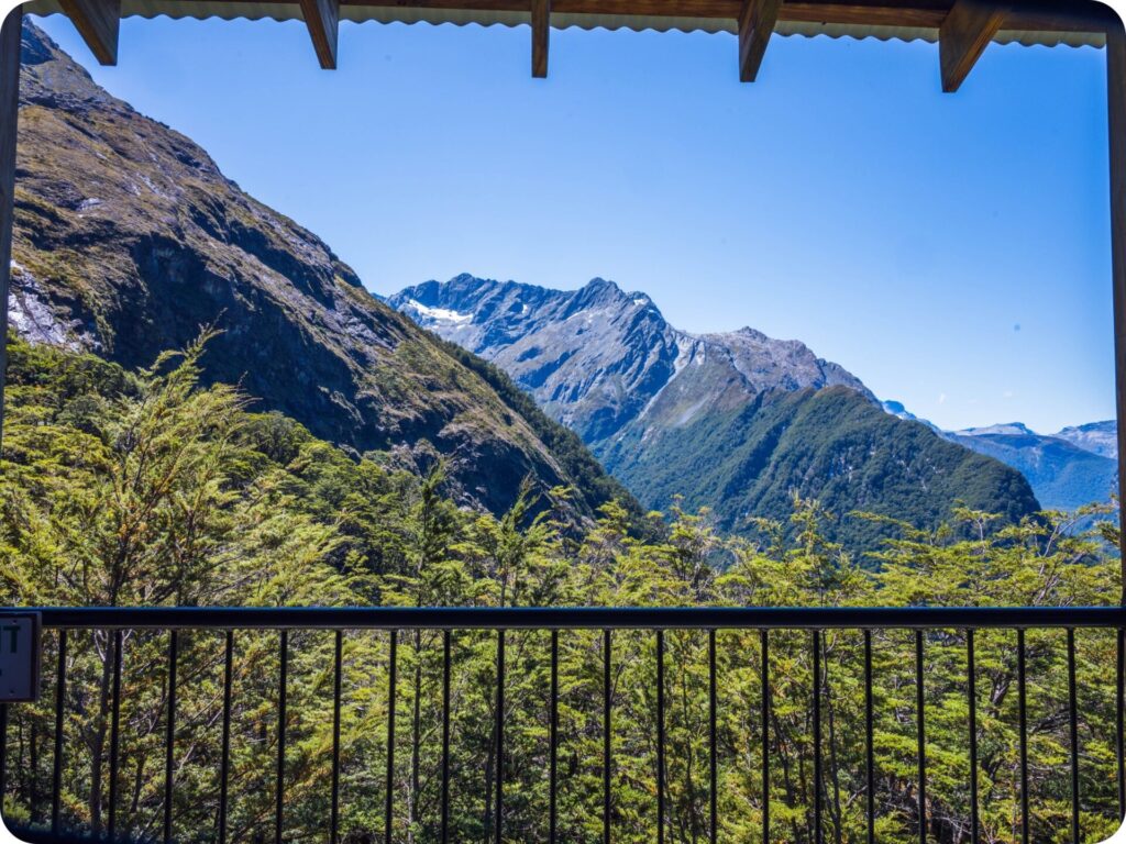
The toilets here are flushing! We still can’t get our heads around that, but It’s pretty awesome. Make sure you stop at the hut for lunch on the veranda, looking out over the trees and into the valley below. It’s the perfect shady spot to reward yourself for the long climb up. Once you are refreshed and have taken in the view, read a few of the boards around the hut telling you about the local wildlife and the development of this incredibly popular hut. There is even an intentions book, which are always fun to fill out.
Routeburn Falls & Beyond

After a well-earned stop at the hut, make sure you walk up the track behind the hut to the Routeburn falls. It’s well worth the effort to climb all the way to the top of the falls so you can really appreciate the view into the valley.
We followed the river up a little further so we could see into the valley, and honestly it was the best decision of our hike! It’s incredible up here and well worth the few extra steps this tacks onto your hike. Tiff kept wanting to go a little further, and the view just kept getting better as we did. The pic below is her satisfaction at dragging Nathan around one more corner for this epic view!
Nature Trail

Once you’ve explored as much as you can around the Routeburn Falls hut, retrace your steps down the steep climb and back to the start at Routeburn Shelter.
If you would like a little extra variety in your return walk home, why not add in the nature walk to get back to that start.
Once you have crossed the Sugarloaf stream on the swing bridge, you’ll see a sign directing you slightly right off the main track and down the Routeburn nature walk. It’s the same length as the rest of the track back but gives you a slightly new trail to walk on through towering red beech trees.
Extra Tips/Info for Routeburn Track
This one is a full day hike, so make sure you pack yourself plenty of food, water and gear to get you through any sudden weather changes. There are toilets at the huts and start of the walk, with one drop toilet before you reach the Forge Flats turn off.
As always, when out in nature, be sure to practice leave no trace. Anything that goes into the park with you comes out as well (this includes apple cores, any type of food scrap, wrappers, etc). Be sure to keep to the trails so you don’t disturb the fragile ecosystems off the trail, and leave rocks sticks and plants as you find them. Please don’t take anything but photographs and leave with nothing extra but memories.
We like to go one step further on leave no trace by making sure we pick up any rubbish we see along the trail, sometimes people slip up and forget to pick up after themselves, so if you see something that doesn’t belong and are equipped to pick it up and correctly dispose of it please do!
Keen for more inspo? Be sure to check out:
- Day Hike – Pouākai Crossing
- What to Pack for an Eco-Conscious Day Hike
- How To Be An Eco-Conscious Hiker